Key features:
- Surveyors for surveyors
3Dsurvey is developed based on 300+ land surveying projects. Tailored to serve specific surveyors’ needs. Cut fieldwork time by up to 100 times.
- Professional tool for daily use
Best price-performance digital surveying tool in the market. Combine with 3Dsurvey Pilot and 3Dsurvey Viewer to get the complete solution: Capture > Process > Analyze > View & Share.
- Hybrid processing engine
Improved engine that utilizes both CPU and GPU for up to 15x faster image processing time. Large dataset support – 1000+ hi-res images.
- Any drone, any camera
Supports any drone & any camera/sensor. Works for aerial & terrestrial data acquisition methods. rTK- and EXIF GPS ready for instant telemetry data import.
- CM-grade accuracy
Capture and recreate natural environment in digital form and survey from the office. Achieve high-resolution outputs with cm-grade accuracy.
- Compatible with third-party sources
Supports working with any third-party point clouds, data from LiDAR, Sonar, SLAM, terrestrial scanners. Seamless workflow for further combination with photogrammetric point clouds.
Functionalities:
- Orthophoto
High-resolution, georeferenced orthophotos. Ideal for daily land surveying projects. Use orthophoto, contour lines, elevation models to create professional survey maps. Compatible with any GIS or CAD software.
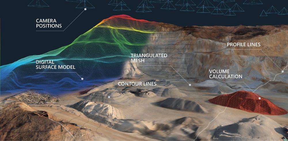
- Volume calculation
Calculate volumes of excavated material in seconds with cm-grade accuracy. Compare and calculate multiple measurements over time or on the fly. 3D visualization and multi-layer volume/stockpile change detection.
- Cross sections
Create vertical cross-sections from point cloud data. Draw a definition line and calculate a single vertical cross-section or calculate multiple transverse profiles with user-defined intervals. One-click export to PDF or DXF.
- Export to any third-party software
Quick export to Google Earth [kml, kmz]. Wide range of export formats for CAD or any other third-party software compatibility [tiff, geotif, jpeg, png, pdf, ply, las, txt, xyz, koo, dxf, etc.]. Further visualization in BIM software [dxf, obj].
- CAD tools
2D and 3D CAD drawing tools. DXF file import/export for any third-party software compatibility. Draw CAD sketches/lines and topo maps directly over textured models and/or point clouds.
Produktentwicklung, Lasertechnik, Sondermaschinenbau, RTK GNSS- Empfänger, LIDAR, Autopiloten, Laserschneiden, 3D-Fräsen, 3D-Drucken, Prototypenbau.
General Laser
Wallgasse 25/8
A1060 Wien
Telefon: +43 (1) 52476-03
http://general-laser.at
Telefon: 015247603
E-Mail: s.pavlov@general-laser.at
![]()